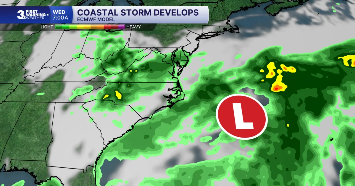
NORFOLK, VA — A soggy stretch is setting up for the middle of the week as a stalled front and an area of low pressure develop off the coast. The National Weather Service forecast from meteorologist Myles Henderson calls for a mix of showers, storms and increasing wind before the system becomes more organized Wednesday and Thursday.
The biggest concerns are heavy rain, localized flooding, strong northeast winds and coastal flooding around high tide. Gusts could top 40 mph in coastal communities and reach more than 30 mph farther inland. Conditions are expected to ease heading into the weekend, but the midweek period looks unsettled and potentially disruptive.
Tuesday brings scattered showers, storms and breezy conditions
Before the coastal storm fully takes shape, Tuesday is expected to stay partly to mostly cloudy with scattered showers and storms building through the afternoon and evening. High temperatures should climb to near 80 degrees, which is about normal for this time of year.
Winds will already be noticeable during the day, blowing from the east at 10 to 20 mph. By tonight, showers and storms are expected to continue, with lows near 70 and northeast winds increasing to 10 to 20 mph and gusts up to 30 mph. That sets the stage for a more impactful setup on Wednesday.
Stalled front and offshore low pressure drive the midweek storm
The key weather feature is a front that stalls over the region while low pressure spins up off the coast. That combination is expected to keep clouds, showers and rain in the forecast Wednesday and Thursday, with periods of heavier rain possible at times.
The setup is important because it keeps moisture focused over the area rather than allowing conditions to clear quickly. As the coastal low strengthens, it will help pull in strong northeast winds and keep the atmosphere unsettled for much of the second half of the week.
That prolonged pattern is why forecasters are flagging both rainfall and wind impacts instead of a short-lived storm. Even if thunderstorms are limited, the rain and wind together could still create difficult travel and water issues in low-lying spots.
Flooding risk grows as rain becomes heavier Wednesday and Thursday
Heavy rain is a major concern in the forecast, especially if repeated showers move through the same areas. Localized flooding is possible, according to the National Weather Service forecast, and that risk increases as the storm lingers into Thursday.
In coastal communities, the stronger northeast flow could produce moderate to major coastal flooding near times of high tide Wednesday and Thursday. That means water may run higher than normal along tidal waterways, bays and low-lying shoreline areas.
The combination of rain and coastal flooding can make impacts more widespread. Streets that usually drain slowly may be more vulnerable, and water levels near the coast may stay elevated longer when winds keep pushing water inland.
Wind gusts could exceed 40 mph near the coast
Wind will be one of the most noticeable effects of the system. Forecasters say coastal communities could see gusts over 40 mph, while inland areas may experience gusts above 30 mph. The strongest wind is expected from the northeast.
Wednesday looks especially blustery, with winds forecast to increase to 20 to 30 mph and gusts up to 40 mph. Those conditions can make driving difficult, especially for high-profile vehicles, and can also lead to minor damage from loose outdoor items if they are not secured.
Strong winds can also worsen flooding by pushing water inland and piling it up along the coast. That is why the forecast ties the wind threat directly to the coastal flood risk for the region.
Weekend improvement brings cooler highs and lower humidity
After the messy middle of the week, conditions are expected to improve heading into the weekend. Highs should settle into the low to mid 70s, with lower humidity making the air feel more comfortable.
That transition suggests the coastal storm will move away and allow a quieter pattern to return. Until then, residents should plan for changing conditions, especially Wednesday and Thursday when rain, wind and flooding concerns are at their peak.
The forecast also shows a brief cooling trend compared with the near-80-degree reading expected Tuesday. While the weekend forecast looks calmer, the immediate focus remains on the storm system and its impacts along the coast and inland.
Tropical update shows Fay weakening and a low development chance in the Atlantic
The tropical outlook included in the forecast says Tropical Storm Fay is weakening over the open Atlantic. Continued weakening is expected, and Fay is likely to become a post-tropical remnant low by late Tuesday.
Forecasters also note a tropical wave expected to move off western Africa by Wednesday. While the environment is not expected to be especially favorable, slow development remains possible as it crosses the far eastern Atlantic.
The development odds are low, with a 0% chance of formation in the next 48 hours and a 30% chance over seven days. For now, the main weather story remains the coastal storm affecting the local area midweek.