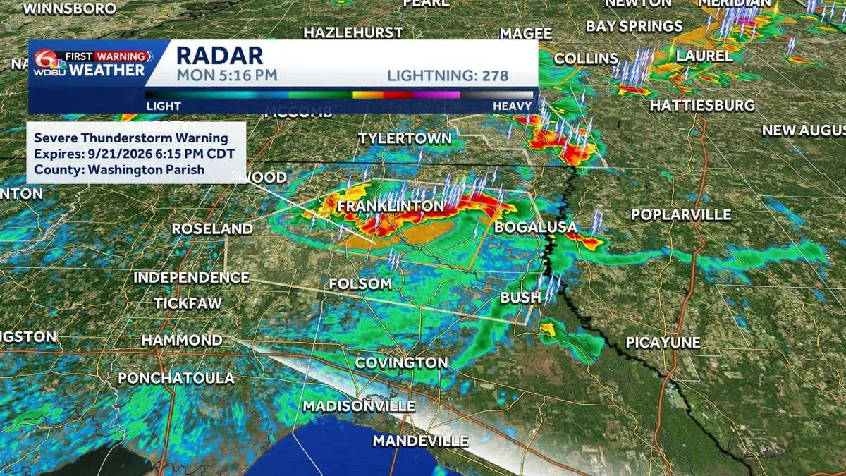
NEW ORLEANS, LA — Severe thunderstorms are moving south across the Northshore, and the National Weather Service has placed Washington Parish under a Severe Thunderstorm Warning through 6:15 p.m.
The warning highlights the immediate risk of damaging wind gusts, frequent lightning and locally heavy rain. Forecasters are also warning that more storms could develop later in the evening during WDSU’s First Warning Weather Impact Day coverage.
Residents are being told to head indoors as storms approach and remain alert for quickly changing conditions.
Washington Parish under warning until early evening
The most urgent alert now in place is for Washington Parish, where the warning remains active until 6:15 p.m. A Severe Thunderstorm Warning means hazardous weather is already occurring or is expected very soon, giving people limited time to react.
The current threats include strong winds that can damage trees or property, flashes of lightning and periods of heavier rainfall that could reduce visibility on roads. Even though the storms are described as drifting south across the Northshore, the warning is specifically tied to Washington Parish and its immediate surroundings.
That makes the next several hours important for anyone with outdoor plans, travel needs or evening activities in the area.
Damaging winds, lightning and heavy rain are the main hazards
The weather service message focuses on three main dangers: wind, lightning and rain. Damaging wind gusts are the most direct threat because they can bring down limbs, knock over unsecured items and create sudden hazards for drivers.
Frequent lightning is another concern, especially for anyone outside or near open areas. Heavy rain may also be brief but intense enough to cause localized flooding or ponding on roads, even when storms do not last long.
Officials have not described tornadoes or hail in this warning. The emphasis is on severe thunderstorms and the fast-changing conditions that can come with them.
Safety guidance centers on getting indoors fast
Residents are being told to move indoors as storms approach. That advice matters because severe thunderstorms can intensify quickly and create dangerous conditions before people have time to prepare.
Staying inside a sturdy building is the safest step during the warning. People outdoors should avoid open fields, tall isolated trees and other exposed places, while drivers should be ready for sudden downpours and sharply reduced visibility.
With lightning part of the threat, officials are also signaling that outdoor events, yard work and other activities should pause until the storm passes.
More storms could develop later in the evening
The weather concerns are not limited to the current warning period. WDSU says additional storms are possible through late evening, which means the atmosphere remains favorable for more rounds of thunderstorm activity.
That could extend the impact window for people across the Northshore and nearby communities. Even if one storm moves out, another could form later and bring renewed wind, lightning and heavy rain.
Because of that, forecasters are treating the evening as an active weather period rather than a short-lived isolated storm.
Northshore communities should stay weather-aware as conditions shift south
The storms are described as drifting south across the Northshore, a sign that the weather pattern is shifting rather than staying fixed in one spot. That movement can make it harder for residents to rely on earlier conditions if they were clear a short time ago.
People in Washington Parish and surrounding areas are being encouraged to keep monitoring weather updates as the situation evolves. A warning can be canceled or extended depending on how storms behave, and new advisories can follow if additional cells strengthen.
For now, the key message from forecasters is simple: take the warning seriously, get inside and stay aware until the severe weather threat passes.