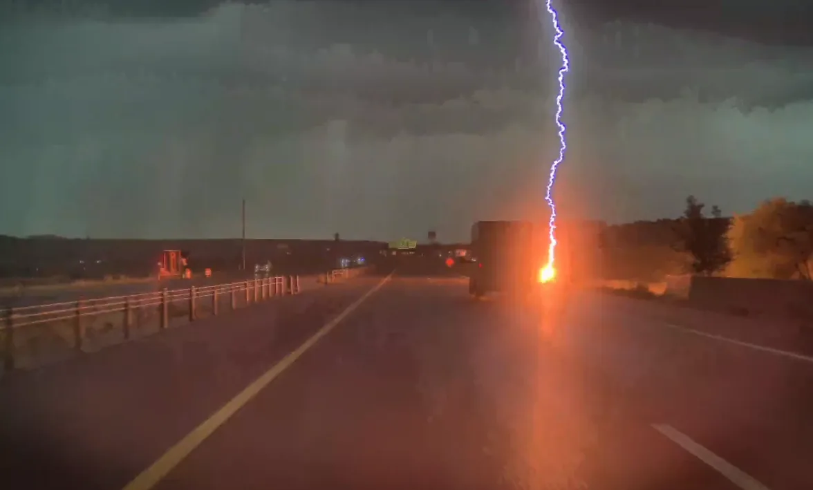
DAVIS COUNTY, UT — A stretch of severe weather in northern Utah produced a dramatic lightning strike on a highway near Weber Canyon, with video showing the bolt landing just feet from a moving truck. The strike happened on US-84 near milepost 87 around 9 p.m., according to National Weather Service data confirmed to KTVX.
The footage, provided by Tucker Ralphs, shows the bolt hitting off the shoulder as the truck traveled along the roadway. The truck appeared to be a commercial vehicle. The scene unfolded as storms moved through the Wasatch Front and Northern Utah, where weather alerts were already in effect.
Video shows lightning hitting beside a moving truck on US-84
The video drew attention because of how close the strike came to the vehicle. Instead of hitting the truck, the lightning landed beside the highway at the edge of the shoulder, underscoring how dangerous fast-moving storms can be for drivers caught outside during active weather.
US-84 near the mouth of Weber Canyon is a well-traveled corridor, and the timing of the strike put motorists at risk during the evening storm period. While no injuries were reported in the provided information, the video captures the kind of sudden hazard that can accompany a severe thunderstorm, especially on open stretches of road.
The lightning strike was not just a visual flash caught on camera. National Weather Service data show it hit the side of US-84 near milepost 87, giving a precise location for the event and confirming that the storm was active enough to generate dangerous electrical activity along the highway.
National Weather Service confirms severe thunderstorm conditions
The National Weather Service confirmed to KTVX that the area did experience a severe thunderstorm. That confirmation matters because it places the lightning strike within a larger weather system that was producing multiple hazards, not just one isolated burst of lightning.
Severe thunderstorms can bring damaging wind, hail, and frequent lightning, and that combination was reflected in the official alerts issued across the region. The storm was active enough to trigger warnings and special statements for several counties as the weather moved through northern Utah during the night.
Although the warnings were later lifted, the NWS confirmation shows that the storm met the criteria for serious weather impacts. For drivers, that usually means the safest approach is to avoid unnecessary travel, slow down when visibility drops, and stay away from exposed areas until conditions improve.
Warnings covered Salt Lake, Davis and Weber counties through the night
Special weather statements and severe thunderstorm warnings were issued for parts of Salt Lake County, Davis County, and Weber County as the storms pushed across the Wasatch Front and Northern Utah. The alerts remained in place through the night before being lifted later on.
The warnings signaled that the weather could turn dangerous quickly, especially for people traveling on highways or spending time outdoors. Storms in this part of Utah can develop rapidly, and the combination of lightning, wind, and possible hail can create hazards over a wide area rather than a single storm cell.
For residents in the affected counties, the alerts served as a reminder that even a short-lived storm can produce significant risk. Drivers in particular would have needed to pay attention to changing conditions, since lightning can strike well away from the most obvious part of a storm.
High winds and hail were part of the official forecast threat
When the National Weather Service issued the warnings, it noted the possibility of high winds and hail. Those are common threats during severe thunderstorms and can be especially damaging when they move across busy roads, neighborhoods, and open terrain.
Wind can make driving more difficult by pushing vehicles, reducing control, and scattering debris. Hail can injure people outside, damage vehicles, and make travel even more hazardous if it falls heavily enough. Combined with lightning, those conditions can turn a routine commute into a dangerous situation in a matter of minutes.
In this case, the lightning strike became the most visible sign of the storm’s intensity, but it was part of a broader pattern of severe weather that affected multiple counties. The official warnings emphasized that the risk was not limited to one isolated road or one single flash.
What the strike means for drivers in sudden mountain storms
The encounter near Weber Canyon shows how quickly severe weather can become threatening on Utah highways. Drivers may see dark skies or hear thunder, but lightning can still strike close to the road without much warning, especially when storms are moving through mountain corridors and nearby valleys.
Even when the strongest warnings are later canceled, the danger during the storm remains real. The video from US-84 is a clear example of why motorists should treat severe thunderstorm warnings seriously, particularly in areas where weather can change from calm to dangerous in a short time.
For anyone traveling through Davis County, Weber County, or nearby parts of the Wasatch Front, the key takeaway is straightforward: when the National Weather Service issues a severe thunderstorm warning, conditions may already be hazardous. Lightning, wind, and hail can all appear quickly and without much room for reaction.