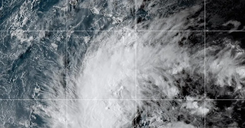
HONOLULU, HI — Tropical Storm Nolo has formed in the Pacific Ocean, and the National Hurricane Center has placed Hawaii’s Big Island under a hurricane watch as the system moves toward the islands. Forecasters said Wednesday that Nolo is expected to strengthen into a hurricane by Thursday and could become a major hurricane by the weekend.
As of Wednesday evening local time, Nolo’s maximum sustained winds were 45 mph. The storm was moving west-northwest, but the hurricane center said a sharp turn to the north and north-northeast was expected Thursday. The Big Island could feel impacts Friday or Saturday.
Rainfall threat raises concern for flooding and mudslides
The National Hurricane Center warned that Nolo could produce extremely heavy rain over the Big Island, with totals of about 15 to 20 inches and as much as 35 inches in some areas. Forecasters said that level of rainfall could lead to catastrophic, life-threatening flooding and mudslides, especially where terrain is steep.
Maui is also in the storm’s path for significant rain. Forecast totals there range from 5 to 10 inches, with as much as 20 inches possible in some locations. Officials said that could also bring life-threatening flooding and mudslides to the island.
The rest of the Hawaiian Islands are expected to receive about 1 to 3 inches of rain, with isolated flooding possible. Even outside the storm’s core, forecasters cautioned that water impacts could still affect roads and low-lying areas.
Forecast track points the storm toward the islands later this week
Nolo’s projected movement gives Hawaii a narrow window before the storm arrives. The hurricane center said the system should begin turning north and then north-northeast on Thursday, a shift that would bring it closer to the Big Island by late Friday or Saturday.
That forecast path matters because a strengthening storm can change conditions quickly as it nears the islands. The center’s latest guidance indicates Nolo will not remain a weak tropical storm for long if the current trend holds.
By the time it approaches Hawaii, the storm could already be at hurricane strength, increasing the risk of damaging wind, rough surf, and widespread rain. Officials have not said exactly how close the center of the storm will come to land.
What a major hurricane would mean for Hawaii
Forecasters said Nolo could reach major hurricane status by the weekend. In hurricane terminology, a major hurricane is a Category 3 storm or higher, with maximum sustained winds of at least 111 mph.
That level of intensity would raise the stakes for the islands, especially if the storm keeps its current track and timing. The combination of strong winds and heavy rain can be especially dangerous in a state where steep slopes and narrow valleys can funnel water quickly.
Even if the center of the storm stays offshore, its outer rain bands could still bring serious impacts. The National Hurricane Center’s warning language reflects concern that flooding and mudslides may become the most immediate threat.
Another active Pacific hurricane season is adding pressure
Nolo is forming while Hurricane Polo continues to spin farther east in the Pacific, off Mexico’s southwestern coast. The overlapping storms underscore how active the Pacific basin has been this season.
Hawaii has already dealt with damaging storms in recent weeks. Earlier this month, Hurricane Lowell brought strong winds and heavy rain to Kauai and Niihau, toppling trees, damaging roads, and leaving thousands without power.
Last month, Hurricane Lala passed near the islands and washed away about 100 homes, triggered landslides, and caused widespread power outages. The recent history of impacts adds context to the new watch now in effect for the Big Island.
Residents are being warned to prepare for fast-changing conditions
The hurricane watch for the Big Island means hurricane conditions are possible within the watch area, and residents should follow official updates closely as Nolo approaches. The National Hurricane Center’s forecast shows the storm could strengthen rapidly enough to bring significant hazards later this week.
With heavy rain, possible flooding, and mudslides in the forecast, officials are focusing on preparedness before the storm gets closer. Areas with steep terrain are especially vulnerable if rainfall totals climb toward the higher end of the projection.
Rain, wind, and surf impacts can all change as the storm’s path becomes clearer. For now, the center’s message is that Hawaii should expect a growing threat through Friday and Saturday, with the Big Island closest to the storm’s projected track.